Amapá: The Most Isolated State in Brazil
Amapá, located in the northern region of Brazil, is characterized by its unique geographical features, which significantly contribute to its reputation as the most isolated state in the country. Entirely bordered by water, Amapá is flanked by the mighty Amazon River to the south and the Atlantic Ocean to the east.
Angelo Mattioli Neto
11/10/20244 min read
Understanding Amapá's Geography
Amapá, located in the northern region of Brazil, is characterized by its unique geographical features, which significantly contribute to its reputation as the most isolated state in the country. Entirely bordered by water, Amapá is flanked by the mighty Amazon River to the south and the Atlantic Ocean to the east. This strategic position creates a natural barrier that limits direct land connectivity with other Brazilian states, making travel and transport a challenge for residents as well as visitors. The surrounding waterways further reinforce the state’s isolation, fostering a distinctive cultural and ecological environment.
Another significant geographical feature of Amapá is Marajó Bay, an important body of water that serves as a critical junction near the capital, Macapá. The bay plays a substantial role in maritime transit, albeit it does not facilitate direct road access to the other more populated areas of Brazil. This geographical reality means that much of Amapá's economy and transportation heavily rely on river and air travel. The state’s location results in its unique demographic composition, with communities often developing in relative seclusion due to the limitations imposed by the landscape.
The natural landscape also encompasses vast rainforests, diverse ecosystems, and marshlands, which constitute a significant part of the Amazon region. These ecological factors not only contribute to Amapá's rich biodiversity but also further accentuate its isolation, as many areas are accessible primarily by river and are occasionally only reachable through extensive navigational routes. This geographic context of Amapá makes it a remarkable state, characterized by its relative inaccessibility yet enriched by vibrant ecosystems and cultural heritage.
The Journey to Macapá: Overcoming Isolation
Traveling to Macapá, the capital of Amapá, is an adventure characterized by the challenges of isolation, largely due to the region's geographical barriers. Located at the northernmost tip of Brazil, Macapá is not easily accessible via well-established road networks. Instead, travelers are faced with two primary modes of transportation: ferry or boat services, which provide a vital lifeline to this remote area.
The most common way to reach Macapá is through boat trips on the Amazon River and its tributaries. Ferries typically operate from nearby cities, such as Belém, which connect to the dock in Macapá. The water routes offer not only a practical means of transport but also an opportunity to experience the stunning natural beauty of the Amazon region. However, these journeys can require significant planning, as schedules and availability may vary, and some may take numerous hours or even days.
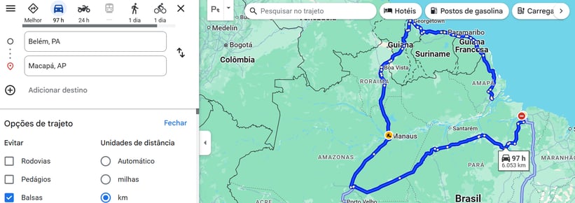
In contrast, attempting to reach Macapá by land (avoiding boats) necessitates a much more extensive journey, often culminating in an extraordinarily lengthy trek filled with obstacles. Travelers looking to bypass water transport must navigate complex road systems that can be poorly maintained, particularly in the rainy season. The land route involves traversing various rural roads, signifying an arduous 97-hour drive from cities like Belém to reach Macapá.
The stark difference between the ease of direct water transport and the exhaustive land alternative epitomizes Amapá's isolation. This contrast underscores the importance of understanding the available travel options before embarking on a journey to this unique Brazilian state. Ultimately, embracing the regional charm and complexity of the journey fosters a deeper appreciation of the challenges faced by those living in Amapá.
Distances and Disconnections: A Comparative Analysis
The geographical isolation of Amapá, the most remote state in Brazil, is primarily illustrated through its significant distances from neighboring capitals. One prominent example is the straight-line distance between Macapá, the capital of Amapá, and Belém, the capital of Pará. This distance is approximately 330 kilometers. However, the reality of traveling from Macapá to Belém is considerably more complex.
For those looking to embark on a land journey, the available roads stretch the distance to an overwhelming length of over 6,000 kilometers. This extensive route necessitates traversing multiple countries and navigating various terrains, which can complicate logistics, travel time, and economic interactions significantly. One might ask how such a lengthy travel distance affects connectivity within the region.
The implications of this geographic separation are manifold. First and foremost, the extended travel time creates barriers for both business and leisure travel. For instance, residents wishing to visit family or conduct business in other regions face logistical challenges that can deter engagement with both local and national economies. Furthermore, the substantial expense associated with such lengthy land travel can limit access to essential goods and services, ultimately perpetuating a cycle of disconnection.
The complex logistics involved in transporting products between Macapá and other capitals also affect economic viability. Businesses may find it less feasible to establish operations or partnerships outside the state, given the time-consuming nature of travel and transport. This disconnect serves to reinforce Amapá's isolation, making it increasingly challenging for the state to forge the vital economic links needed for growth and development.
Cultural and Economic Effects of Isolation
Amapá, as Brazil's most isolated state, experiences significant cultural and economic effects stemming from its geographic seclusion. This isolation has led to the development of a unique cultural identity that is distinct from that of other regions in Brazil. The local communities have cultivated traditions, customs, and lifestyles that resonate deeply with their surroundings and history. For instance, indigenous influences combined with African and Portuguese heritage manifest in the unique festivals, music, and culinary practices, which continue to be an essential part of Amapá's cultural fabric.
The geographic barriers also shape social interactions and relationships within Amapá. The sense of community is robust, with residents often relying on one another for support and collaboration due to limited external connections. This strong communal bond fosters resilience, enabling locals to maintain their traditions while adapting to the demands of contemporary life. Additionally, the state boasts a wide variety of local arts and crafts, which are both a reflection of its cultural identity and a means of sustenance for many artisans.
Economically, Amapá faces numerous challenges attributable to its remoteness. The logistics of transporting goods and accessing services can be burdensome, often leading to higher prices for everyday necessities. Trade opportunities are limited, which affects both local businesses and the overall economic growth of the region. However, Amapá's isolation also presents certain economic opportunities, particularly in the realm of tourism. The state's rich biodiversity, national parks, and indigenous cultures attract visitors seeking unique experiences, which can help stimulate the local economy.
Moreover, Amapá's natural resources and the possibility of sustainable tourism represent potential avenues for economic development. Residents are increasingly looking to leverage their unique geographical characteristics to promote eco-tourism and sustainable practices, which may provide long-term benefits. In conclusion, while Amapá's isolation poses significant challenges, it simultaneously plays a critical role in shaping the state's cultural identity and economic prospects.